Historic nautical charts are invaluable documents that offer a glimpse into the maritime history and the evolution of navigational practices. These charts, often created centuries ago, are more than just maps; they are rich in detail, artistry, and historical significance. For mariners, historians, collectors, and enthusiasts, the benefits of using and studying these charts are vast and varied. In this article, we delve deep into the numerous advantages of utilizing historic nautical charts.
A Window into Maritime History
One of the most significant benefits of historic nautical charts is their ability to provide a detailed view of maritime history. These charts reflect the knowledge and understanding of the world at the time they were created. They depict the exploration routes of early mariners, the discovery of new lands, and the development of trade routes. By studying these charts, we gain insights into the maritime challenges and triumphs of the past, including the hazards that ancient sailors faced, such as uncharted waters, dangerous coastlines, and treacherous reefs.
Understanding the Evolution of Cartography
Historic nautical charts are a testament to the evolution of cartography. They showcase how map-making techniques and tools have progressed over centuries. Early charts were often rudimentary and based on limited knowledge, with large portions of the world left blank or filled with speculative information. As time progressed and exploration expanded, these charts became more accurate and detailed. By studying these charts, we can trace the advancements in navigation, the improvement of geographical knowledge, and the shift from decorative maps to more functional and precise navigational aids.
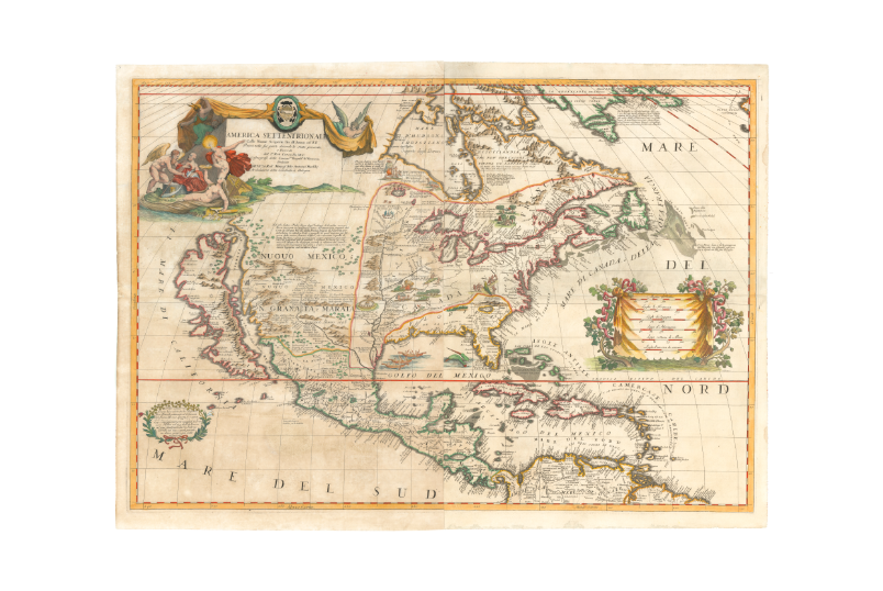
Aesthetic and Artistic Value
Beyond their practical use, historic nautical charts are also appreciated for their aesthetic and artistic qualities. Many of these charts were hand-drawn and meticulously decorated, often featuring elaborate illustrations of sea monsters, ships, and compass roses. The artistry involved in creating these charts makes them valuable pieces of art, coveted by collectors and displayed in museums around the world. The unique blend of art and science in these charts provides a fascinating insight into the way our ancestors viewed and represented the world.
The Craftsmanship Behind the Charts
The creation of historic nautical charts was a labor-intensive process that required immense skill and precision. Cartographers of the past relied on tools such as compasses, sextants, and astrolabes, along with their observations and reports from explorers. The resulting charts were not just practical tools but also works of art, with every detail carefully crafted. The craftsmanship of these charts adds to their historical value, making them treasured artifacts of human ingenuity and creativity.
Educational and Research Purposes
Historic nautical charts are a goldmine for researchers and educators. They serve as primary sources for studying the history of exploration, trade, and colonization. Historians use these charts to understand the geopolitical landscape of different eras, including territorial disputes and the establishment of trade routes. For educators, these charts are invaluable tools for teaching students about the history of navigation, the age of exploration, and the development of global trade networks.
Reconstructing Historical Voyages
One of the most intriguing uses of historic nautical charts is in the reconstruction of historical voyages. By comparing old charts with modern maps, researchers can trace the routes taken by famous explorers like Christopher Columbus, Ferdinand Magellan, and James Cook. These reconstructions provide a deeper understanding of the challenges faced by these explorers, including the navigational errors and the discoveries they made. Such studies also shed light on the impact of these voyages on global history, from the spread of cultures to the establishment of new trade connections.
Cultural and Geopolitical Insights
Historic nautical charts are more than just maps; they are reflections of the cultural and geopolitical perspectives of their time. They reveal how different civilizations understood and interacted with the world. For instance, European charts from the Age of Exploration often depicted newly discovered lands with European place names, reflecting the colonizers’ view of the world. On the other hand, charts from other cultures, such as Chinese or Arabic maps, offer alternative perspectives on geography and navigation.
Understanding Colonial and Trade Impacts
The study of historic nautical charts also provides insights into the impacts of colonialism and global trade. These charts document the expansion of European empires, the establishment of colonial outposts, and the development of trade routes that connected distant parts of the world. By analyzing these charts, we can better understand the economic and cultural exchanges that shaped the modern world, as well as the often devastating effects of colonization on indigenous populations.
Preservation of Maritime Heritage
Collecting and studying historic nautical charts is also a way to preserve maritime heritage. These charts are tangible links to our seafaring past, and their preservation ensures that future generations can continue to learn from and appreciate this aspect of human history. Museums, libraries, and private collectors play a crucial role in the preservation of these charts, ensuring that they are protected from deterioration and remain accessible to the public.
The Role of Digital Archiving
In recent years, digital archiving has become an important tool in the preservation of historic nautical charts. By digitizing these charts, institutions can protect the originals from wear and tear while making the charts more accessible to a global audience. Digital archives allow researchers, students, and enthusiasts to explore these charts in detail, often with tools that enable zooming in on intricate details and comparing different versions of the same chart.
The Allure for Collectors
For collectors, historic nautical charts are prized possessions. Their rarity, historical significance, and artistic value make them highly sought after in the world of antiques and collectibles. Collectors are often drawn to the stories behind the charts—whether it’s the tale of a daring explorer or the legacy of a famous cartographer. Owning a historic nautical chart is like holding a piece of history, a tangible connection to the past.
Investment Value
In addition to their historical and artistic value, historic nautical charts can also be valuable investments. As the interest in maritime history and antiques grows, the demand for these charts has increased, driving up their market value. Collectors who invest in these charts not only acquire a piece of history but also a potentially appreciating asset.
Conclusion
Historic nautical charts are more than just tools for navigation; they are windows into the past, works of art, and valuable educational resources. Their benefits extend beyond their original purpose, offering insights into history, culture, and the development of human knowledge. Whether you are a historian, educator, collector, or simply a lover of maritime history, the value of these charts is undeniable.
Go to Check – https://neatlinemaps.com/